|
Updates are highlighted
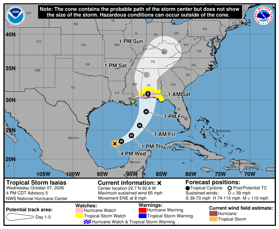
Wednesday, October 7, 4 p.m. - Santa Rosa County Public Safety continues to monitor Tropical Storm Isaias for further development and its potential impact on Santa Rosa County.
Key messages
- Santa Rosa County is under a Hurricane Watch and Storm Surge Watch.
- Know Your Zone! Visit Santa Rosa County's Know Your Zone for evacuation zone information.
- Review your disaster plan and make sure it includes your pets.
- Check your disaster supply kit and replenish necessary items. Remember, be one-week ready!
- Halfway full is halfway there - residents and visitors should keep their gas tanks at least half full during hurricane season to ensure they have enough fuel to evacuate as soon as possible without worrying about long lines at gas stations and to avoid gas shortages before a storm.
- Residents should make preparations now ahead of any potential impacts from Tropical Storm Isaias. Residents should have preparations completed by Friday afternoon, October 9.
- According to the National Weather Service Mobile Office, there is wind threat to cause considerable roof damage, mobile homes damaged, many large trees snapped or uprooted, along with road signs blown over, some roads impassable due to debris, and large areas of power outages.
- The earliest reasonable time of arrival for tropical storm winds is Friday morning along the coast and Friday afternoon further inland.
- Heavy rain could impact the local area late this week ahead of this system, with more rain over the weekend.
- The extent of the heavy rain will highly depend on the exact track.
- Heavy rainfall could lead to flash flooding, especially in urban areas or where storms repeatedly move over the same locations.
- A high rip current risk is in effect for Navarre Beach through at least Saturday, October 10. Rip currents can sweep even the best swimmers away from shore into deeper water. Always swim near a lifeguard.
- Turn around, don't drown! Never cross a flooded roadway because you can't see whether the road has been damaged.
- Those living in areas prone to flooding should be prepared to quickly move to higher ground if warnings are issued.
- Heavy rain can cause flooding of low-lying spots, underpasses, and poor drainage areas.
Sand
The county's public works department has sand available on a first-come, first-served basis at the following locations:
- The corner of Leisure Street and Citrus Drive in Navarre
- Tiger Point Park in Gulf Breeze (1370 Tiger Park Lane)
- Pace Fire-Rescue in Pace (4773 Pace Patriot Boulevard)
- The corner of Pine Forest Road and Carroll Road in Milton
Residents must provide their own sandbags and shovel. Bags can be purchased at many local hardware stores. For information on how to make and use sandbags, visit the Federal Alliance for Safe Homes (www.flash.org). While sandbags can help mitigate to an extent, buying flood insurance is the best protection against flood loss.
Floods are the nation's most common and costly natural disaster and cause millions of dollars in damage every year. And get it sooner rather than later - flood insurance requires a 30-day waiting period.
Cancellations
- The Library Advisory Board Meeting is cancelled for Thursday, October 8 at 11 a.m. at the Library Administration Center/Family History & Research Center, 6275 Dogwood Drive in Milton.
- Household Hazardous Waste (HHW) Amnesty Day at the South Santa Rosa Service Center and Waste Tire Amnesty Day at the Central Landfill in Milton are cancelled for Saturday, October 10.
- Santa Rosa County Animal Services has cancelled the Fall Fest Adoption Event originally scheduled for Saturday, October 10.
Santa Rosa County Offices
- Santa Rosa County Offices will be closed Friday, October 9.
Navarre Beach Pier
- Navarre Beach Pier will be closed Friday, October 9 and Saturday, October 10.
Santa Rosa County Clerk of Court and Comptroller
- The Clerk of Court offices in Santa Rosa County will close at 2 p.m. on Thursday, October 8 and will remain closed Friday, October 9. Normal operations are expected to resume on Monday, October 12.
Santa Rosa County District Schools
- Schools will remain open, Thursday, October 8. However, all after-school and extracurricular activities scheduled for Thursday, October 8, are canceled. Latchkey will remain open Thursday, 10/8, through 6:00 p.m.
- Out of an abundance of caution and with the safety of our students, employees, and families as our highest priority, all district schools and offices will be closed Friday, October 9th. This includes athletic events, practices, clubs, meetings, and other school-sponsored activities.
- All district and school-sponsored activities scheduled for Saturday, October 10, are also canceled.
- As a reminder, Monday, October 12, is a Planning Day and there is no school for students that day.
Santa Rosa County Tax Collector
- All offices of the Tax Collector will be closed beginning at 1 p.m., Thursday, October 8 and remain closed Friday, October 9. The office will also still be closed on Monday, October 13 for staff training.
Courts of the First Judicial Circuit in Santa Rosa County
- In anticipation of inclement weather, the Courts of the First Judicial Circuit in Santa Rosa County will close at 2:30 p.m. on Thursday, October 8, and will remain closed all day Friday, October 9.
Gulf Islands National Seashore
- Opal Beach Complex will close for day use October 7 at Noon.
Bridges
- Bridges ONLY close when sustained tropical storm force winds are observed by FDOT or law enforcement officials. If one bridge closes, it does not mean all bridges will close.
- For state and federal road closures (I-10, Hwy. 87, Hwy. 89, Hwy. 90, Hwy. 98, Hwy. 4, Avalon Blvd.), see www.FL511.com.
Shelter
- A shelter is not open at this time.
Prepare now. Make sure all family members know the plan.
- Have multiple ways of receiving alerts and monitor official sources for information.
- Clear clogged rain gutters, downspouts, and storm drains to help with the flow of water during heavy rain during hurricane season.
- Limit damage caused by high winds by removing any debris from your yard and trimming your trees, shrubs, etc.
- Every home should have a NOAA weather radio, the first line of defense before relying on alerts through a smartphone.
- Smartphone weather apps are also an excellent delivery source of severe weather information and other disaster updates - especially in the overnight hours. Santa Rosa County's alert app - AlertSantaRosa.com - provides updates on emergency incidents (hazardous materials as well as severe weather) in the county at addresses of your choice (work, school, home, etc).
- Be sure that you have not disabled your alerts on your phone and that it is fully charged and within reach. If you use the "Do Not Disturb" feature on your phone at night, turn it off so that any emergency calls may come through.
For current weather events, visit www.weather.gov/mob. For information on preparing for disasters, visit www.santarosa.fl.gov/974/Emergency-Management.
# # #
Serving our community, committed to excellence.
www.santarosa.fl.gov
|